A fresh Polar Vortex is spinning back to life over the Arctic, and meteorologists are already watching closely. Pressure levels are dipping, temperatures in the stratosphere are falling, and if history is any guide, the setup could have big consequences for Winter 2025/26 across North America and Europe.
Why the Polar Vortex Matters
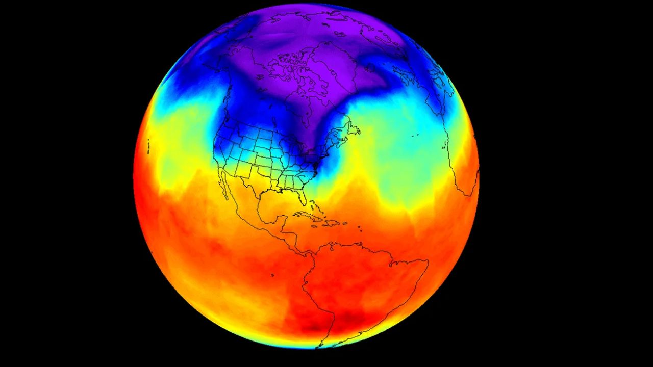
Every autumn, as sunlight fades over the pole, the Arctic begins its deep freeze. The sharp temperature contrast between icy polar air and milder mid-latitudes creates a powerful, swirling low-pressure system stretching from the surface into the upper atmosphere. This circulation—what we call the Polar Vortex—acts like a lid, locking cold air in the Arctic when strong, or letting it spill south when weak.
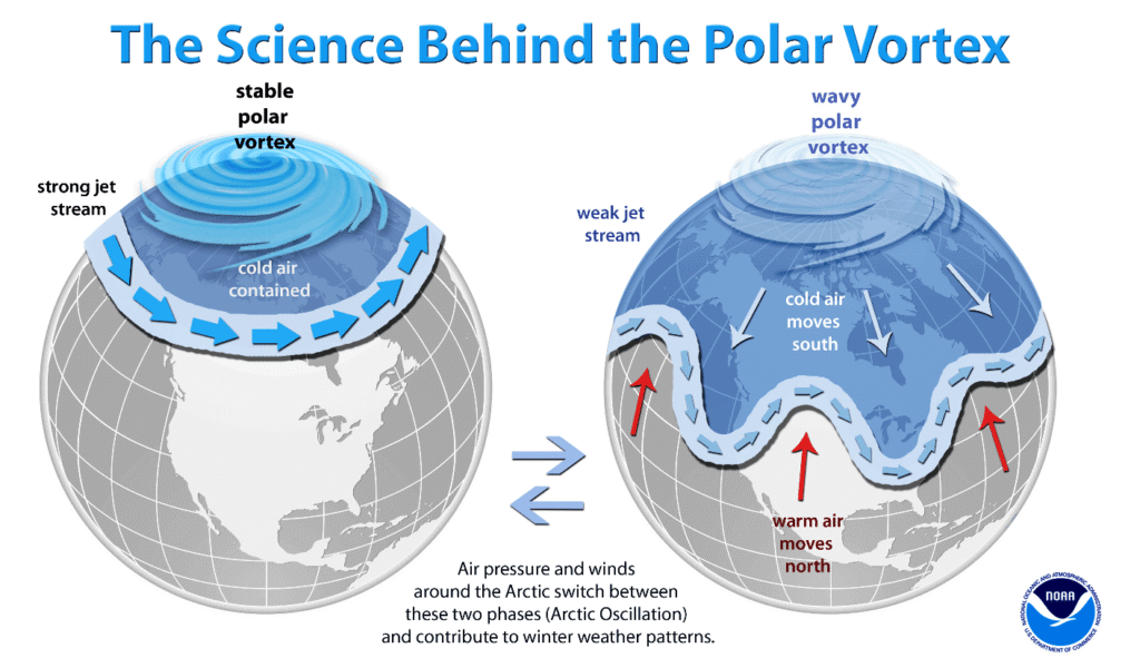

Think of it as the gatekeeper of winter weather. A strong vortex corrals frigid air near the pole, leaving the U.S. and Europe with milder, storm-free spells. A weak or disrupted vortex, on the other hand, can unleash those icy blasts, bending the jet stream and fueling snowstorms across the mid-latitudes.
The stakes are high. Sudden stratospheric warming events, when the vortex abruptly weakens or collapses, have historically brought brutal cold waves—like the infamous 2014 “polar vortex” event that sent Chicago into a deep freeze and disrupted life across much of the U.S.
Signs of a New Arctic Player

According to recent NASA stratospheric wind speed analyses, the Polar Vortex is in its early growth phase. Typically, stratospheric winds strengthen from late September into November, peaking in early winter. This year’s winds are currently running slightly weaker than the long-term average, echoing last year’s setup.
Meanwhile, stratospheric temperatures are dropping fast at the 10mb level—about 30 kilometers above the surface. Forecasts suggest that a cold “core” is consolidating over the pole. The colder the core, the more robust the vortex becomes.
Here’s a quick breakdown of what’s unfolding:
| Factor | Current Status (Sept 2025) | Implication for Winter 2025/26 |
|---|---|---|
| Stratospheric winds | Weaker than average | Could mean less stability in the vortex |
| Stratospheric temperatures | Rapid cooling, core forming | Indicates vortex is strengthening seasonally |
| Oceanic patterns (El Niño/La Niña) | Transitioning toward neutral-to-La Niña | May enhance jet stream waviness, adding stress to the vortex |
| Historical pattern | Similar to last year’s early-season setup | Raises chance of mid-winter disruption |
What This Could Mean for Winter 2025/26

If the vortex strengthens and holds, expect a calmer, warmer winter across much of the U.S. and Europe, with Arctic chill bottled up north. But if it falters—especially mid-season—those “cold arms” of displaced air could drag winter storms deep into the lower 48 states or Western Europe.
Climate signals like the Pacific ENSO phase and North Atlantic Oscillation will play key roles, but the early data hints at a dynamic season ahead, with a heightened risk of disruptions. That could translate to a colder, snowier second half of winter in regions that have recently seen milder Decembers.
Why Forecasters Care
For meteorologists, the Polar Vortex isn’t just an atmospheric curiosity—it’s a forecasting goldmine. Long-range models often struggle beyond 10 days, but stratospheric signals give valuable seasonal clues weeks to months in advance. The ongoing cooling trend is one such signal, suggesting the stage is set for volatility.
As NOAA explains in its seasonal outlooks, vortex behavior often dictates whether winter ends up mild or severe. And with energy markets, agriculture, and transportation all hinging on weather, keeping tabs on this high-altitude powerhouse is as much about economics as snowflakes.