A golden cloud is rolling in—no, it’s not from a Hollywood western set. It’s real, and it’s dust from the Sahara Desert, making its way across the Atlantic to the Southeast of the United States. Sounds surreal, right?
Skies turning red, glowing sunsets like something out of Star Wars, and yet, behind the beauty lies a not-so-glamorous truth: it’s dust, and lots of it. And for anyone with asthma or allergies, it’s not just a weather event—it’s a red flag.

Let’s break down what this dust cloud really is, where it’s coming from, and what you should expect in the next few days.
Dust
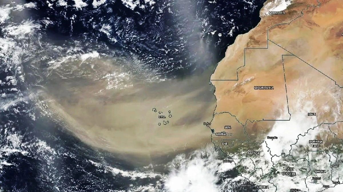
The Saharan dust cloud, also known as the Saharan Air Layer (SAL), is a huge mass of dry, dusty air that forms over the Sahara Desert in North Africa. Every summer, trade winds pick up millions of tons of sand and carry it across the Atlantic Ocean. This year? It’s coming in strong.
Covering roughly 8,000 kilometers, this cloud is on a full transoceanic trip—from the scorching dunes of Africa to the warm skies of the Americas. It’s already been spotted over the Caribbean and is now on track to hit parts of the U.S., including Florida, Louisiana, Alabama, and Mississippi.
Composition

What’s in this mysterious cloud? Not just plain sand. It’s a mix of mineral dust, organic particles, and microscopic remnants that can rise up to 4 kilometers thick. These tiny particles can travel for days and spread across entire regions, making the air visibly hazy and often giving the sky an unusual reddish or golden tint.
Here’s a look at what’s inside the cloud:
| Component | Description |
|---|---|
| Mineral Dust | From Sahara sand, rich in iron |
| Organic Matter | Plant particles and biological bits |
| Microparticles | Invisible dust, harmful to lungs |
Health
Now for the not-so-pretty side. This dust isn’t just scenic—it’s irritating, especially for people with respiratory problems. Asthma sufferers, allergy-prone individuals, and even those with sinus issues may find it harder to breathe during peak dust days.

The reason? These particles are small enough to enter the lungs and settle there. For someone already struggling to breathe, it can be like adding weights to your lungs. Think of it as breathing through a straw—then imagine that straw is full of dust. Not fun.
Tips
So what should you do if you’re in one of the affected areas?
Here’s what experts and health authorities recommend:
- Limit outdoor activity during peak dust hours
- Keep windows and doors closed
- Use air purifiers or ACs with clean filters
- Wear a mask outdoors if needed
- Lightly mist fabric surfaces at home to trap dust
Yep, a simple spritz of water on your couch or bed can help reduce airborne particles—just don’t overdo it and flood your living room.
Impact
Believe it or not, these clouds aren’t all bad. According to NOAA, the dry air and dust particles actually reduce hurricane formation. They interrupt the moisture flow that hurricanes need to build up strength.
So while you may be sneezing, nature might be using this moment to hit pause on tropical storms. It’s like the atmosphere is multitasking—one hand blowing dust, the other blocking hurricanes.
Visibility
Another noticeable effect? The sky. As the cloud thickens, visibility drops. You might see foggy, reddish skies during the day and warmer nights than usual. That’s because the dust acts like a thermal blanket, trapping a bit of heat.
In parts of the Gulf Coast, especially Florida and southern Louisiana, drivers and pilots alike should be cautious. Visibility could drop enough to cause minor transportation delays.
Timeline
So, when’s all this happening?
According to current weather models, the Saharan dust will reach the U.S. mainland between Wednesday and Thursday. The thickest concentration will likely hit midweek, with particles lingering in the air until Saturday or Sunday.
Here’s a quick timeline:
| Date | What to Expect |
|---|---|
| Wednesday | Dust cloud begins reaching U.S. |
| Thursday | Peak dust density, red skies |
| Friday | Continued reduced air quality |
| Saturday-Sunday | Dust begins to fade |
Wonder
This cloud, although disruptive, is also a reminder of how connected our planet is. A windstorm in Africa leads to glowing sunsets in America. A weather pattern that starts in the Sahara ends with photographers snapping otherworldly shots in Florida.
And yes, for stargazers, sky watchers, and amateur photographers—this is your moment. The sunsets will be wild. Think golden haze, red-tinted skies, and a landscape that feels more like Tatooine than Tallahassee.
Just remember, behind that magic glow is a lot of microscopic dust. So while your eyes feast, let your lungs rest.
FAQs
What is the Saharan Air Layer?
It’s a dry, dusty air mass from the Sahara that travels west.
Is the dust cloud harmful to health?
Yes, especially for people with asthma or allergies.
When will the dust reach the U.S.?
Between Wednesday and Thursday this week.
How long will it stay?
Until Saturday or Sunday, according to forecasts.
Can it affect hurricanes?
Yes, it can actually reduce hurricane formation.